Thermographic Surveys with the F550-IR-Go4 DRONE
At last available: the F550-IR-Go4 Complete Solution for Themographic inspections with the Drone and the GoPro 4
Thermographic detections with the DRONE
F550-IR-Go4 DRONE: the Professional Solution.
Analist Group is proud to present the new "F550-IR-Go4" Complete Solution for Thermographic Detections with the DRONE. The best infrared and video technology combined with a powerful, stable and easy to fly DRONE (DJI F550). Innovation and technology in a UNIQUE Solution that can be brought to you by Analist ONLY. It includes a ready-to-fly F550 DRONE + a FLIR TAU 2 336 9mm Thermocamera + a GoPro Hero 4 Black Edition + a Remote Controller + a Video Recorder + 2 wireless Monitors for live viewing + a Gimbal stabiliser for GoPro and TAU.
Download the Solution Technical Details ►

The F550-IR Drone
Ready-to-fly, stable and complete.
The F550 hexacopter represents a versatile and safe choice: ready-to-fly, stable and easy to pilot. It includes a Gimbal stabiliser for the FLIR TAU 2, a remote controller, a video recorder for the TAU 2 and a wireless monitor for live viewing.
You will not need any other accessory to carry out your thermographic detections.
We have devised and tested a Complete and versatile Solution, suitable for all types of thermographic surveys. We are the only who can offer you the tranquility of a worry free Solution. All you have to do is fly.
NOTE: The F550-IR-Go4 ready to fly DRONE is available with the FLIR TAU 2 radiometric or non radiomentric thermal Camera.
Request Information ►
Download the Solution Technical Details ►


FLIR TAU 2 336 9mm
Light and versatile infrared Thermocamera.
The Solution includes the new FLIR TAU 2 with a 9mm lens thermocamera which combined with the F550 DRONE, becomes a powerful and versatile Solution. With our F550-IR-Go4 solution it is possible to carry out in the most fast and accurate way thermogarphic detections of photovolttaic panels, thermographic detections for heat dispersion or humidity of buildings and constructions, it is also possible to assess the condition of vineyards, lands and coltivated fields. Try the most innovative technology!
NOTE: The F550-IR-Go4 ready to fly DRONE is available with the FLIR TAU 2 radiometric or non radiomentric thermal Camera.
Request information ►
FLIR TAU 2 Technical Details ►
Download the Solution Technical Details ►
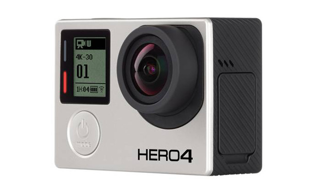
GoPro HERO 4
Performance at a completely new level.
GoPro HERO 4 is the GoPro cutting-edge videocamera. Thanks to its extraordinary quality and the new powerful functions, with GoPro 4 you can capture and exalt the most important moments of your life.
The most important features are the incredible 30fps 4K and the 50fps 2.7K and the most elevated frame frequency from 1080p to 120fps.
Download the Solution Technical Details ►
Find out more about the Thermogarphic Solution without the GoPro ►

How it works
Fly, Film and it's done.
Our Solution has been devised to enable you to work fast, accurately and professionally. The video recorder installed on the DRONE records the thermal images produced by the FLIR TAU 2 themal camera. In the meantime the GoPro HERO 4 films the most spectacular videos. All you have to do after is import the survey on your computer in order to easily create Reports, videos and so on. The complete workflow will be fast and simple.
Request Information ►
Download the Solution Technical Details ►
Use of the Solution
No limits, new business opportunities.
Our F550-IR GO4 Solution is used in many fields and implementations: heat dispersion, detection of moisture damage, agrcultural suveys and surveys in inacessible areas and many more.
Our Customers have been able to offer new services and consequently enhance their business opportunities. They have improved the level of the services they offer thus also improvinfg their brand image. Why not access the business opportunities that thermography can offer!
Request information ►
Download the Solution Technical Details ►
Do You Need a Topographic Survey Software?

FAQs
Frequently Asked Questions.
HOW HIGH CAN MY F550 IR-Go4 FLY?
You can fly your F550 IR-Go4 up to approximately 300 m. Baring in mind that the flight up takes 6m/s and the descent 2m/s. At higher altitudes, the air gets thinner, which will make control more difficult. Please note that flying above that height will bring you into airspace with manned aviation such as helicopters and planes, and can be highly dangerous. However, depending on the type of application, there are different ideal altitudes: for Land Survey flights 50 meters or slightly above is enough; for Thermographic Inspection of Photovoltaic Panels Systems, a flight between 25 and 50 meters in altitude is ideal.
HOW FAST DOES IT FLY?
It is capable of flying at a maximum speed of approximately 5m/s. The ideal speed however, depends on the type of application we use the drone for. In Photogrammetry, for example, the target is always clear and sharp footage. Theoretically the higher you fly, the faster you can go without blurry images. If you fly too near to your relief object at a high speed, there is the risk of blurry footage, which will negatively affect the quality of your Survey.
HOW LONG CAN THE F550 IR-Go4 FLY?
When flying in good weather conditions at a speed of approximately 5m/s the battery life is of about 12/15 mins. The battery can be changed very quickly and easily thanks to the new integrated battery compartment. It is advisable to have one or two extra batteries for vast Survey areas.
HOW MUCH WEIGHT CAN IT LIFT?
The F550 IR-Go4 is designed to be capable of carrying up a total of about 2 kilos of payload (like an action camera setup). This ready-to-fly set up has been specifically designed for immediate and efficient use. It has been tested for maximum stability and highest performance. Adding extra weight reduces flight time, stability and general efficiency.
DOES IT WORK WITH ANDROID TABLETS AND PHONES?
YES. The Android software works with any device that has GPS and that can support an OTG cable and has 4.0 Android System or above. Android recommended: Samsung Galaxy S3, S4, Note 2, Note 3 or phones of similar configuration. Read the article ►
CAN I USE IT WITH MY iOS™ DEVICE (IPHONE AND IPAD)?
Absolutely YES. iOS recommended: iPhone 4s, iPhone 5, iPhone 5s, iPhone 6, iPhone 6 Plus, iPod touch 5 (available but not recommended: iPad 3, iPad 4, iPad mini). Read the article ►
WHAT IS THE "Return Home" Feature?
The F550 IR-Go4 Drone flies back to take off position in case of loss of control. The flight radar displays the current position of the F550 IR-Go4 in relation to the pilot. Exceeding the control range of the remote control will trigger ‘Return-to-Home’, that is if connection between the drone and the pilot is lost the F550 IR-Go4 will automatically fly back to its takeoff point and land safely.
HOW MUCH WIND CAN IT FLY IN?
Flying a device this small in heavy wind conditions is always going to be a challenge. The F550 IR-Go4 with GPS enabled are designed to stay in place and they will do their best to maintain a set position. In our experience, we have been able to fly in winds of up to 15 km per hour without significant degradation of control. If there is a considerable amount of wind, it will put a heavier stress and load on the motors and batteries and your flight time will most likely be adversely affected. Read the article ►