Walk in with Matterport
... and leave 15 minutes later with the Schematic Floor Plan
With Analist 2022 you can produce the most accurate DWG plan ever seen.
See what you can do
Take a look at the Floorplan
Prospects with a click
... lots of photos ... endless prospects
With AnalistPhoto use the ability of the high resolution Aspheric Matterport camera to capture high resolution photos and correct them to vectorize elevations.
From the Point Cloud to Technical Drawing
Get the most from your point cloud.
The New Analist 2022 Features enable you to generate technical drawings and other docs with ease and accuracy.
Matterport Camera per il rilievo di interni
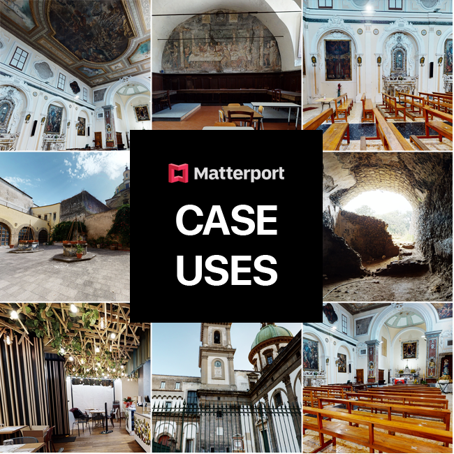
Watch the case uses.
You can use Matterport for any type of survey in any condition. Watch the results.
Two floor detached house >
Religious building >
Historical and religious building >
Matterport Experience.
Read the outstanding experiences from professionals who use Matterport for their projects.
FAQS
The camera performs 360 ° photos and scans thanks to the built-in 3D precision sensor in order to obtain accurate measurements. Look!
Matterport manages the alignment of the stations automatically. An adequate overlap between one station and the next should be guaranteed. Normally, the recommended maximum distance is about 4 meters but in correspondence with the doors it is advisable to position the camera in the middle between the two rooms. This takes a few more stations (about 10 seconds). If there is no alignment, the MatterportCapture App signals the problem and all is required is to move the camera for a more suitable positioning.
This article explains the assisted alignment procedure in detail.
The acquisition is by project. Technically, there isn’t a definite limit. Matterport suggests keeping the maximum number of stations per project within 200 acquisitions. For larger acquisitions simply create multiple projects. It is important that the 'positioning' of the scanning stations is within a radius of 4 meters. This allows for an exceptionally realistic representation of the design and a high measurement quality.
Yes. The generation of the cloud occurs automatically by requesting the MatterPack that contains the cloud in color xyz format which is imported into ReCap and into all programs to read the free format. This way it is possible to extract floor plans and sections in Analist.
The Floor Plans, Sections and Elevations are generated Analist CLOUD software with the Autodesk technology inside. See how >
The suggested maximum number of scans is 200, for larger projects just create more projects.
The output formats are both photos and scans: 2D Snapshots, 360º Photosphere, MP4 or GIF Schematic Floor Plans, OBJ File, Point Cloud.
The Matterport Pro2 camera does not use Bluetooth. The Wi-Fi connection has a range of about 10-12 meters. This distance allows the operator to find a location in the shooting phase so as not to be filmed during acquisition. To optimize the transfer speed, it is suggested to approach the camera after about 10 seconds of acquisition in order to allow rapid transfer and alignment and move on to the next station.
Big. From 900 m² to up to 4500 m² for empty spaces. The interesting aspect is the speed of acquisition and consequently the productivity at an extremely low cost.
The Matterport Pro2 3D is a scanner and an ultra-defined camera. If there is little light, just illuminate the darkest point and move the light source and the camera each time.
The Matterport Pro 2 3D camera is essentially a scanner. It can be placed at arbitrary heights for each acquisition.
The Matterport camera technology allows you to generate 3D files faithful to reality and floor plans with millimeter precision.
It is possible to detect condo with no limit of dimensional capacity. See how >
The project is available as long as the subscription is active. If it is interrupted and subsequently restored, the projects are restored too. In Analist 2022 a function has been added to load SVG files and obtain the plan and 3D representation. Watch the video
The Matterport Pro2 3D camera is designed for scanning interior spaces. To use camera for outdoor spaces it is necessary to reduce the distance to maintain good alignment. If the scans are not aligned, delete them and try again. With Analist, a feature has been added that allows you to use Matterport externally.
|
|
Rilevamento 3D |
Sensore 3D a luce strutturata (infrarossi) |
Tempo di acquisizione di 20 secondi per scansione/sweep |
99% di precisione all'interno dell'intervallo |
Portata massima di 15 piedi (4,5 m) |
Registrazione dati 3D: automatica |
Risoluzione profondità: 10 punti per grado (3600 punti all'equatore, 1800 punti al meridiano, circa 4 milioni di punti per panoramica) |
Fotografia |
Output Pano Pixel: 134,2 MP, equirettangolare |
Esporta immagini fino a 8092px x 4552px |
Obiettivo: 4K Full Glass |
Campo visivo 360° (sinistra-destra) x 300° (verticale) |
Costruzione |
Custodia in plastica nera con struttura resistente |
Prodotto negli Stati Uniti |
Dimensioni: 9.0" H, 10.25" W, 4.38" D (230 x 260 x 110 mm) |
Peso: 7,5 libbre (3,4 kg) |
Colore nero |
Dati
|
WiFi per trasferire i dati dalla fotocamera al dispositivo iOS tramite l'app Capture |
Wi-Fi 802.11 n/ac 5 Ghz |
Batteria |
Batteria agli ioni di litio |
Può eseguire la scansione per 8 ore con una sola carica |
Tempo di ricarica di 4,5 ore |
GPS |
Incluso |