Thermographic Inspections with the DRONE
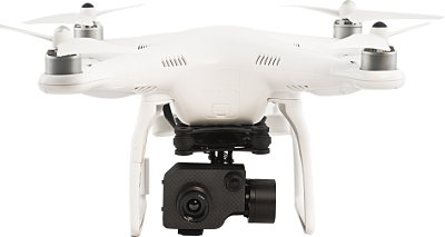
The ultimate generation 336-IR UAV for Thermographic Surveys. The ready-to-fly Phantom 2 Vision with the FLIR TAU 2 infrared thermal camera.
Thermographic Surveys with the DRONE
Phantom 336-IR UAV: the Compact Solution for Aerial Thermography.
The Phantom 336-IR is the new Analist Group Drone for many applications which require professional thermal imaging such as solar panel inspections, heat dispersion in buildings and tracking missing persons.
The Phantom 336-IR is a compact solution with a 4 engine ready-to-fly Drone, a FLIR TAU 2 336 9mm Thermal Camera, a Gimbal TAU with an integrated second camera, a Radio Control, an SD Video Recorder and wireless monitor for live view, standard (video) and IR (infrared).
Download the Solution Technical Details ►
 IMPORTANT: The Phantom 336-IR ready to fly DRONE is available with the FLIR TAU 2 radiometric or non radiomentric thermal Camera.
Application Case
PLC Photovoltaic Panel System Inspection.
PLC System, world leading company in renewable energies, uses the Phantom 336-IR Drone to inspect its photovoltaic panel system.
When companies need to monitor a large system of photovoltaic panels or an extended area the solution is undoubtedly the Phantom 336-IR. To achieve consistent benefits, both in trems of time saving, inspection accuracy and the possibility to carry out regular flights with the 336-IR Drone identify anomalies and so intervene with a radiometric thermal camera.
Read our complete BLOG article ►
Watch the Video on YouTube ►
Phantom 336-IR
The most compact thermographic Drone in the world.
The Phantom 336-IR integrates the FLIR TAU 2 336 9mm thermal camera and a microcamera for real vision. The thermographic video (for the 336-IR NON-Radiometric version) and IR radiometric images (for the 336-IR Radiometric version) are directly saved on an SD card on board, thus avoiding interference.
Find out the difference between Radiometric and NON-Radiometric Cameras ►
The monitor clasped to the Radio Control enables real time image visualization.
The great stability makes it incredibly simple to pilot even to the less expert users.
NOTE: The Phantom 336-IR ready to fly DRONE is available with the FLIR TAU 2 radiometric or non radiomentric thermal Camera.
Request information ►
Download the Solution Technical Details ►
Do You Need a Topographic Survey Software?


FLIR TAU 2 336 9mm
The high sensitivity IR Thermal Camera.
The Phantom 336-IR includes the FLIR TAU 2 thermal camera with a 9mm lens. This thermal camera has a 336x256 pixels resolution and sensitivity levels below 50mK. The temerature ranges fromi -25°C to 100°C in High Gain mode and from -40°C to + 550°C in Low Gain mode. Its incredibile features make it ideal for thermographic inspections of photovoltaic panels, buildings and industry inspections, detection of thermal anomalies of the research of missing persons.
NOTE: The Phantom 336-IR ready to fly DRONE is available with the FLIR TAU 2 radiometric or non radiomentric thermal Camera..
Request information ►
Gimbal for TAU 2 with microcamera
Visual and infrared image Stabilizer.
The Phantom 336-IR mounts a 2 axis gimbal which includes the FLIR TAU 2 thermal camera and a microcamera. You can control the Gimbal directly from the remote control during the flight. The body made of carbon fiber reduces the gimbal's weight, increasing flight time. The two engines allow to stabilize the thermographic images minimizing oscillations and vibrations.
NOTE: The Phantom 336-IR ready to fly DRONE is available with the FLIR TAU 2 radiometric or non radiomentric thermal Camera.
Request information ►


How it works.
Fly, Shoot, Done.
The Phantom 336-IR as an all-in-one solution to work fast, accurately and professionally. During the flight the DVR records the IR video directly onto the SD memory card. Once the flight is over it can be copied onto a computer for further processing.
Request information ►
Download the Solution Technical Details ►
Automatic Piloting
Programmable from iPad or PC
The Phantom 336 -IR can be flown from a distance up to 1,5 km. By installing the DJI APP (available for free for iOS and Android) you'll be able to automatically manage the Drone's route, setting up to 16 WayPoint ans monitoring all the flight parameters.
Request information ►
Do You Need a Topographic Survey Software?


Smart Battery
Safe and reliable.
The LiPo (Lithium Polymer) 5200mAh battery, has up to 18 minutes. The unique and innovative DJI battery, provides data saving great capacity, protection from overload and download, as well as maintanance reminders and an extremely safe and reliable battery.
The integrated battery compartment allows battery changes in a matter of seconds and you are immediately ready to fly.
Request information ►
Radio Control
Total Control.
The improved Radio Control is equipped with many new features. A control dial, TRAINER PORT, built in rechargeable LiPo battery with a 2000mAh, level LED indicators, block function of the valve which keeps it in during landing are all incuded.
Use DJI Lightbridge to control your UAV or to connect the Radio Control to your computer with the TRAINER PORT to carry out a flight simulation and practice your flight techniques.
The new Remote Control is compatible with the Phantom 2 Vision + and the Phantom 2.
Request information ►


New Compass
Top Flight Safety.
The new anti-static compass has been developed to be even more reliable and safer. The compass is positioned in a protective shell to help shield it in any flight condition.
Request information ►
Improved Power
New engines, propellers and ESC.
With the new enhanced engines, the new propellers and the very new ESC POWER and CONTROL SYSTEM have been incredibly implemented. The new Phantom is able to reach up to 200g/arm (when using a 3S LiPo battery), allowing an easy management of a higher PAYLOAD.
Request information ►

Integrated GPS
Precision and stability.
The integrated automatic GPS pilot offers position holding, provides altitude lock along with stable hovering giving you constant stable flights so you can focus on getting the shots.
Request information ►


Return home
Automatic return to take off position.
If the connection between the Phantom 2 and the controller is lost during the flight and piloting is impossible, the automatic fail-safe protection function of the system will action and will fly the Phantom back and safely land at its takeoff position.
It is also possible to manually set up the One Key Go Home function to activate the automatic return to takeoff position by simply moving the lever.
How to set up Automatic Return ►
Request information ►
No fly zone
Safety above all.
In order to increase flight safety and prevent accidental flights in restricted areas, the new firmware Phantom 2 series includes a No Fly Zone feature.
When the il Phantom is too close to a restricted area (e.g. an airport), the system prevents the UAV from flying. All flight functions are disabled. You need to move away from the "No Fly Zone" in order to fly. This aspect makes the Phantom even safer.
Request information ►

FAQs
Frequently Asked Questions.
Are the thermographic data recorded on board of the drone?
Yes. The thermographic data are recorded on board the drone, in order to avoid interference during the transmission. Anything the camera visualizes is transferred to the pilot during the flight.
In what format is the thermographic data recorded?
The non-radiometric solution produces standard video files in .mp4 format and thermographic IR video files in an .asf format. The radiometric solution produces thermographic IR video files in .tmc format. The data of the Radiometric version can be visualized and processed with Thermoview and FLir Tools Software to develop professional reports.
What software can be used to analyze this data?
The software included in the solution are ThermoView (for both radiometric and non radiometric versions) and FLIR Tools (only for the radiometric version).
Can the Gimbal be controlled via the remote control?
Yes. The Gimbal stabilizer can be controlled from the remote control.
Is it possible to switch from thermographic to regular video stream on the remote control?
YES. It is possible to switch from the thermal image to the real image video stream.
What are the specs for the microcamera?
The camera mounted on board is compact and very light and it offers extraordinary high quality video in the .mp4 (mpeg-4) format.
How many batteries are included?
You can purchase all the batteries you wish. The current version includes 2 batteries for the UAV.
Is it possible to get this system with a Phantom 3, is there anything planned?
The aircraft used is the Phantom 2. Other aircraft such as the Vision + or the Phantom 3 are not yet convenient for this type of operations. The radio included in the 336-IR is a Professional Taranis with vocal messages, with over 2 km high reliability.
UAV FAQs
Frequently Asked Questions.
HOW HIGH CAN MY Phantom 336-IR FLY?
You can fly your Phantom 336-IR up to approximately 800/900 m. Baring in mind that the flight up takes 6m/s and the descent 2m/s. At higher altitudes, the air gets thinner, which will make control more difficult. Please note that flying above that height will bring you into airspace with manned aviation such as helicopters and planes, and can be highly dangerous. However, depending on the type of application, there are different ideal altitudes: for Land Survey flights 50 meters or slightly above is enough; for Thermographic Inspection of Photovoltaic Panels Systems, a flight between 25 and 50 meters in altitude is ideal.
HOW FAST DOES IT FLY?
It is capable of flying at a maximum speed of approximately 5m/s. The ideal speed however, depends on the type of application we use the drone for. In Photogrammetry, for example, the target is always clear and sharp footage. Theoretically the higher you fly, the faster you can go without blurry images. If you fly too near to your relief object at a high speed, there is the risk of blurry footage, which will negatively affect the quality of your Survey.
HOW LONG CAN A Phantom 336-IR FLY?
When flying in good weather conditions at a speed of approximately 5m/s the battery life is of about 20/25 mins. The battery can be changed very quickly and easily thanks to the new integrated battery compartment. It is advisable to have one or two extra batteries for vast Survey areas.
HOW MUCH WEIGHT CAN IT LIFT?
The Phantom 336-IR is designed to be capable of carrying up a total of about 2 kilos of payload (like an action camera setup). This ready-to-fly set up has been specifically designed for immediate and efficient use. It has been tested for maximum stability and highest performance. Adding extra weight reduces flight time, stability and general efficiency.
DOES IT WORK WITH ANDROID TABLETS AND PHONES?
YES. The Android software works with any device that has GPS and that can support an OTG cable and has 4.0 Android System or above. Android recommended: Samsung Galaxy S3, S4, Note 2, Note 3 or phones of similar configuration. Read the article ►
CAN I USE IT WITH MY iOS™ DEVICE (IPHONE AND IPAD)?
Absolutely YES. iOS recommended: iPhone 4s, iPhone 5, iPhone 5s, iPhone 6, iPhone 6 Plus, iPod touch 5 (available but not recommended: iPad 3, iPad 4, iPad mini). Read the article ►
WHAT IS THE "Return Home" Feature?
The Phantom 336-IR Drone flies back to take off position in case of loss of control. The flight radar displays the current position of the Phantom 336-IR in relation to the pilot. Exceeding the control range of the remote control will trigger ‘Return-to-Home’, that is if connection between the drone and the pilot is lost the Phantom 336-IR will automatically fly back to its takeoff point and land safely.
HOW MUCH WIND CAN IT FLY IN?
Flying a device this small in heavy wind conditions is always going to be a challenge. The Phantom 336-IR with GPS enabled are designed to stay in place and they will do their best to maintain a set position. In our experience, we have been able to fly in winds of up to 15 km per hour without significant degradation of control. If there is a considerable amount of wind, it will put a heavier stress and load on the motors and batteries and your flight time will most likely be adversely affected. Read the article ►
Request Information
Fill out the form below to request further information on the Solution for Thermographic inspections with the DRONE.