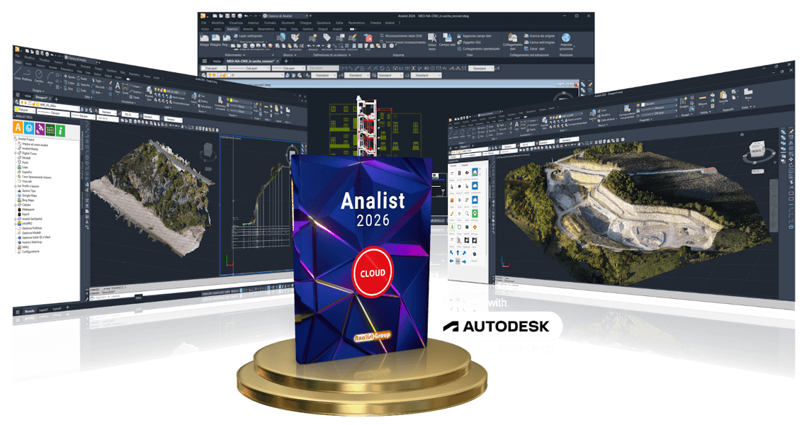
Analist 2026
Surveying, Cadastre, Design, Documentation
Your Software for every Survey
A Single Working Environment
Analist 2026 is the complete software for surveyors, engineers, architects, geomatics professionals, and land technicians. Designed to simplify and enhance every phase of surveying, from data collection to graphical output, it allows you to:
- Import data from GPS, total stations, drones, and laser scanners for integrated survey source management.
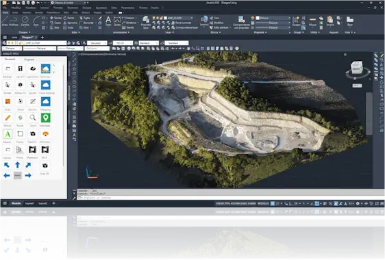
- Fully manage point clouds to generate sections, 3D models, and architectural surveys.
- Process elevation profiles, contour lines, orthophotos and digital terrain models (DTM/DSM).
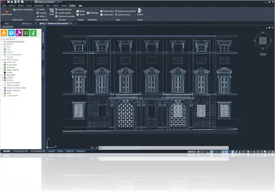
- Create architectural drawings such as floor plans, elevations, and sections in a CAD environment.
- Manage cadastral maps and field books for updating and verifying cadastral data.
- Analyze special surveys: road accidents, construction sites, thermographic surveys, and precision farming.
What's New in Analist 2026
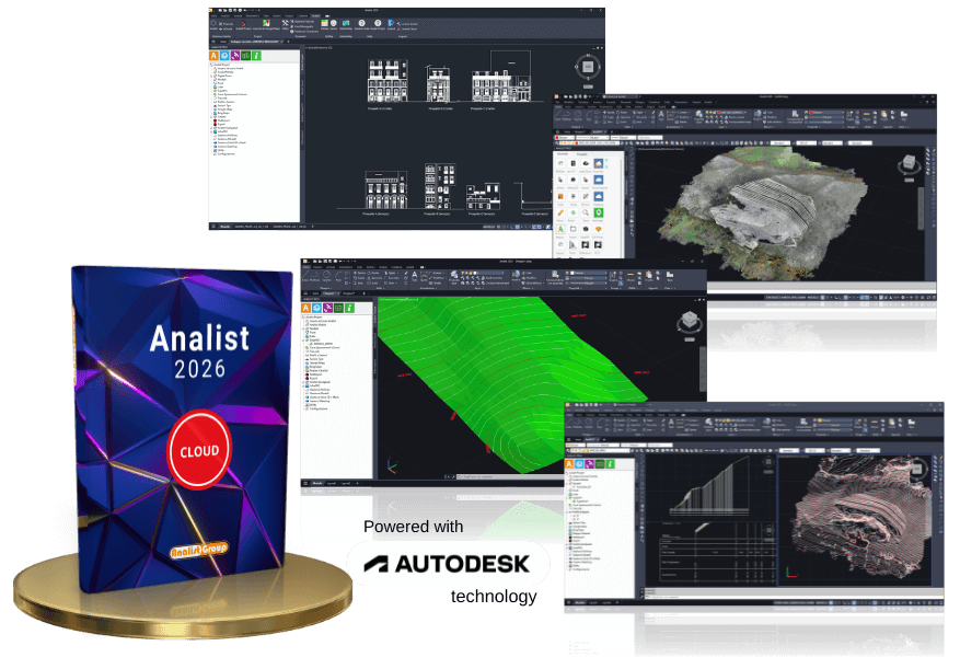
A Single Solution for an Integrated Workflow
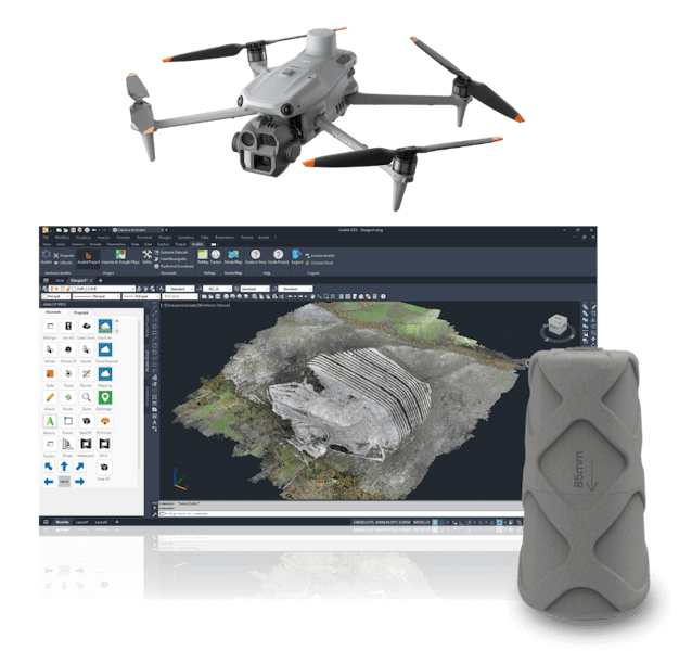
Analist imports and processes data from Drones, Laser Scanners, 3D Cameras, Topographic GPS, and Total Stations.
The Winning Solution for Surveying
- 3D terrain model generation from drone, GPS and surveying instruments data
- Advanced management of quarries, earthmoving, and excavation/fill volumes
- Automatic creation of profiles, sections, and contour lines
- Surface import from Google Maps, Bing Maps, Tinitaly, and other DSM/DTM services
- Integration with E57 point clouds
- Optimized workflow for high-precision topographic surveys
- Landslide and slope monitoring, excavation progress tracking for quarries or construction sites
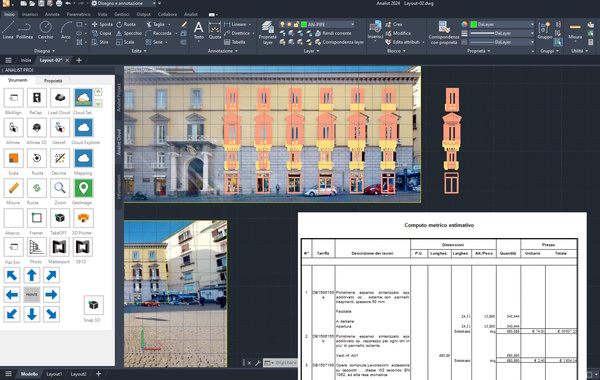
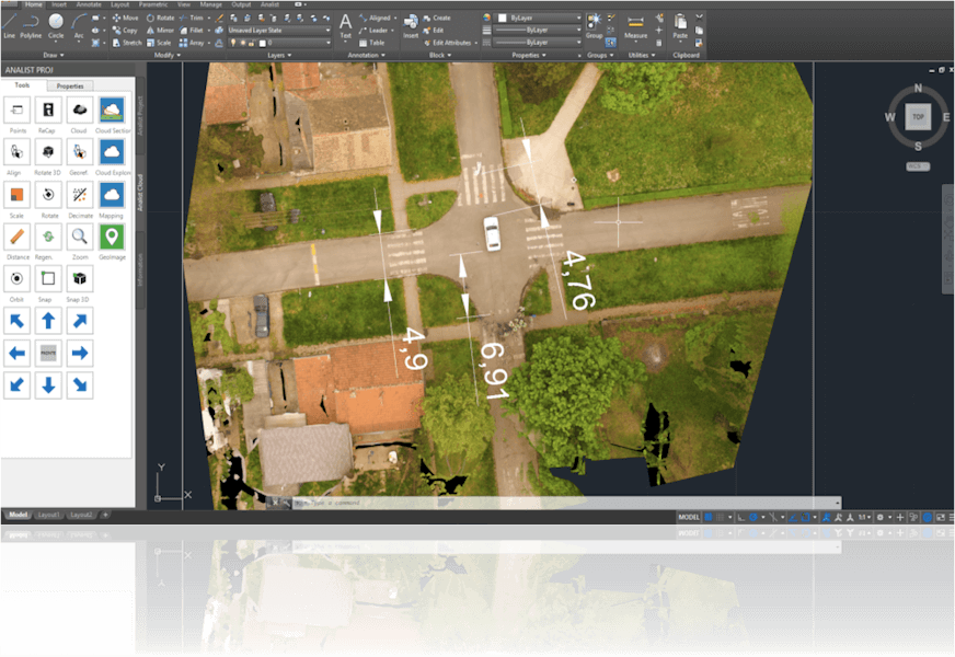
Analist and Architectural Survey
With Analist you get the most out of digital architectural surveying: automatic perspective correction of facade images, precise extraction of architectural sections from 3D point clouds, conversion of Matterport .svg files into .dwg, and generation of plans, elevations, and executive sections.
- Automatic perspective correction of facade images for quick and efficient elevation drawings
- Extraction of plans, elevations, and sections from 3D point clouds
- Conversion of Matterport .svg files into ready-to-design .dwg format
- High-precision architectural sections and orthographic views
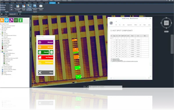
The Complete Workflow for Thermography
- Anomaly calculation compliant with IECTS62446 Standard
- Direct upload of thermal orthophotos from drones or manual inspection
- Identification of hotspots and thermal anomalies
- Detailed technical reporting with charts and geolocation of hotspots
- Thermal image visualization and temperature measurement directly on images
- Professional analysis of photovoltaic systems and industrial roofs
Cadastre and Pregeo with Analist
- Management and editing of Pregeo field books
- Transformation of geographic and cadastral coordinates
- Updated and compatible cadastral mapping
- Integration with inDocfa for simplified DOCFA submissions
- Automatic import and export of field books
- Precise management of fiducial points
- Integration with TAF (fiducial points and monographic sheets) and DIS (mutual distances)
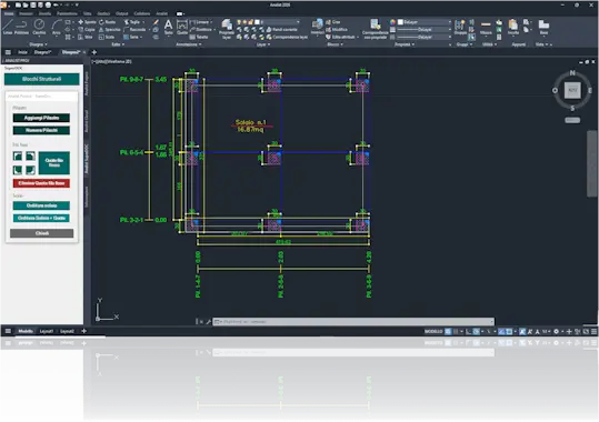
Advanced tools for documentation, structural management, and accident survey
- Traffic accident reconstruction with drone surveys, plans, and automatic measurements
- Territorial monitoring for urban, suburban areas and road construction sites
- Structural dynamic blocks for fast and smart management of pillars, slabs, and fixed lines
- Automatic technical documentation with organized plans and construction details
- Document production ready for printing and delivery, directly from surveys or digital twin
Our Solutions

Subscription 12 months

License Perpetual
Analist Modules
Analist Matterport
Analist InfraPro
Analist Photo
Analist TakeOff
Analist Framer
Analist Abacos
Analist Agro
More Power with Analist Modules
Analist 2026 includes modules designed to speed up and enhance your work thanks to advanced features and optimized workflows. Increase productivity by automating complex tasks with one of these modules.
What is Analist InfraPro?
Analist InfraPRO is the module for professional thermographic analysis. Designed for technicians, engineers, and professionals in the photovoltaic and industrial sectors, it allows the creation of detailed thermographic reports, with precise temperature measurements and quick identification of hotspots.
- Compliant with IEC TS 62446 standard for photovoltaic system certification.
- Real-time detection of hotspots and damaged cells on solar panels.
- Direct upload of thermal orthophotos from drone or manual inspections.
- Visual and numerical analysis of thermal images with temperature measurement.
- Comprehensive georeferenced reports with charts and thermal maps.
- Ideal for predictive maintenance of industrial and photovoltaic systems.

What is Analist AGRO?
Analist AGRO is the Analist CLOUD module dedicated to precision agriculture. It analyzes the health status of crops in real time using the NDVI index, processed from drone and multispectral sensor data, for targeted and sustainable interventions.
- Get real-time NDVI maps.
- Monitor crops and water stress to improve yields.
- Integrate analyses into agricultural workflows for sustainable management.

What is Analist TakeOff?
Analist TakeOff is the module that transforms technical drawings into automatic quantity takeoffs. Ideal for companies and professionals, it allows you to extract quantities and measurements directly from the project, optimizing time and resources.
- Create quantity takeoffs from DWG or PDF drawings.
- Smart quantity management for specifications and estimates.
- Accelerate the workflow from survey to job accounting.
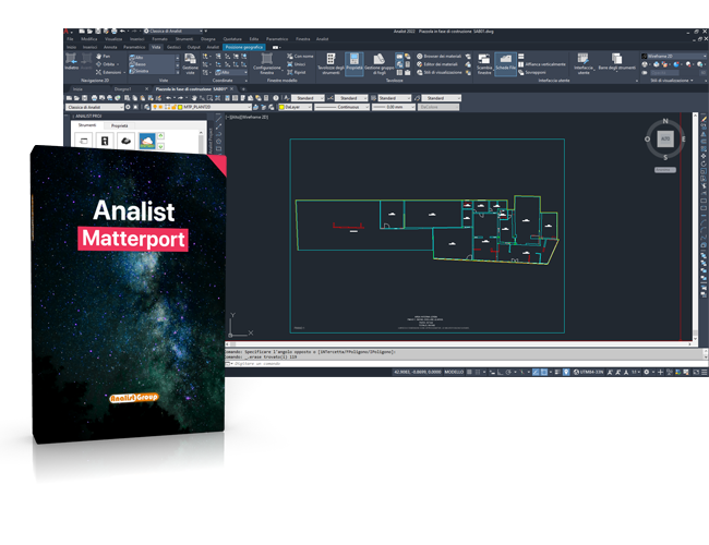
What is AnalistMatterport?
AnalistMatterport is the module that automatically converts surveys generated with Matterport technology into ready-to-use DWG files. It eliminates manual SVG conversion time and optimizes the post-production workflow.
- Convert from SVG to DWG in one click, no intermediate steps.
- Automate surveying with a smart and integrated solution.
- Speed up the design process.
What is Analist Framer?
Analist Framer is the module for designing curtain walls. It allows you to quickly create professional elevation drawings with modular schemes, profiles, and hatches ready for production.
- Design complex façades easily and quickly.
- Insert modules and profiles with an intuitive interface.
- Optimize technical documentation for production.
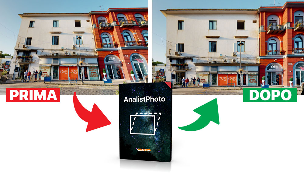
What is AnalistPhoto?
AnalistPhoto is the Analist module that allows automatic perspective correction of images captured with a smartphone, drone, or camera. It reduces optical distortion and allows precise measurement directly on the calibrated photo.
- Correct perspective in one click with a guided procedure.
- Reduce image distortion caused by optics.
- Measure and vectorize directly on the corrected photo.
The Right Software for Your Survey
Analist allows you to stand out in every field: it’s designed to always make the difference
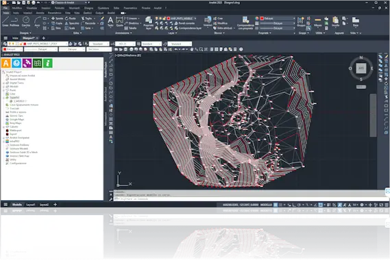
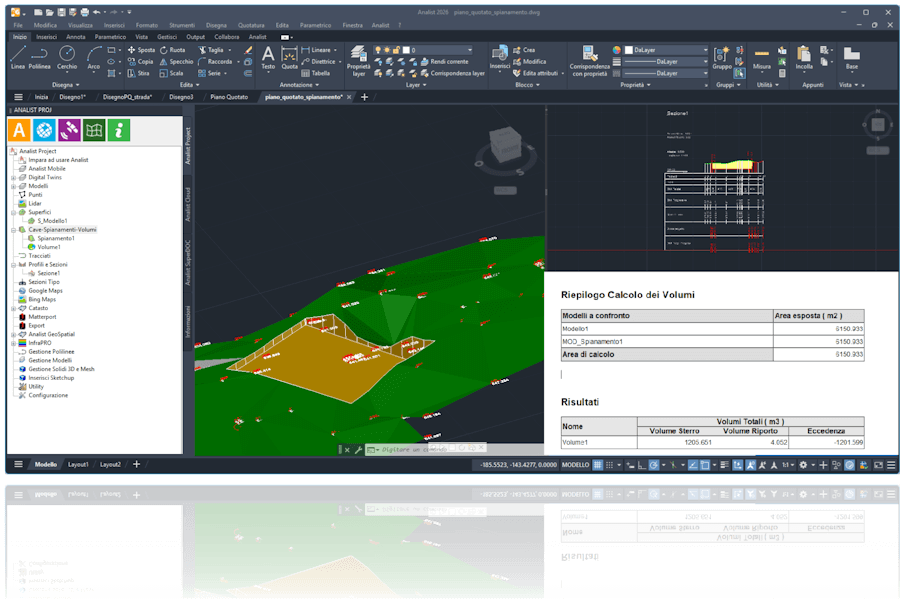
Topographic Surveys and Terrain Modeling
Analist 2026 is the professional software for land surveying and design, compatible with Total Stations, GNSS, Drones, and Laser Scanners. It enables integrated data management, ideal for surveyors, engineers, and land planners.
Advanced Features for Surveying and Terrain Analysis
- Import Point Clouds and Data Files
- Generate Digital Terrain Models (DTM/DSM)
- Create Contour Lines
- Calculate Volumes (cut/fill) and Leveling
- Draw Profiles and Cross-Sections
- Analyze Earthworks by comparing pre/post-execution surfaces
- Import Models from Google/Bing Maps for preliminary studies
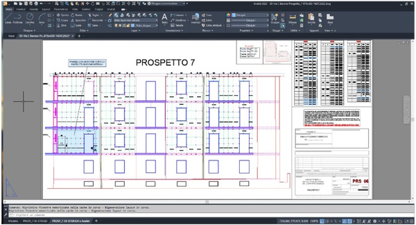
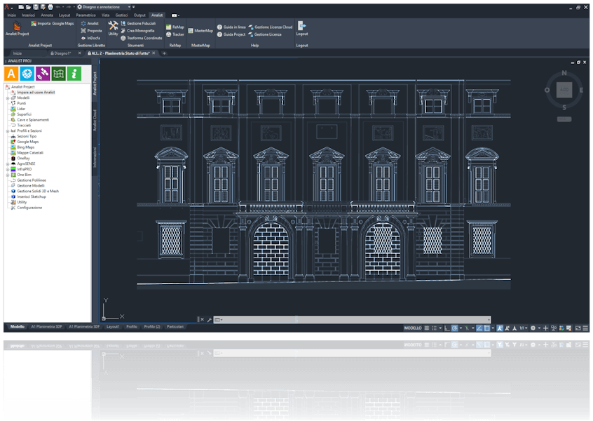
Architectural Survey
Analist 2026 optimizes the entire Architectural Survey workflow: from data import to automatic generation of technical drawings.
Tools for Architectural Design
- Extract plans, sections, and elevations from Point Clouds
- Create Architectural Sections
- Triangulation Functions
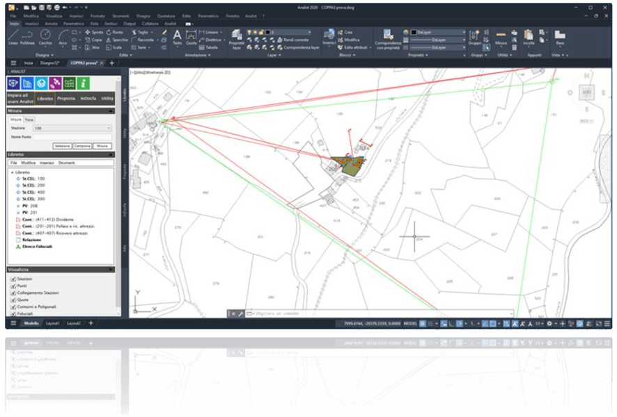
Advanced Cadastre Management
Analist 2026 automates and simplifies every phase of cadastre management: from compiling the field book to sending it to Pregeo. Compatible with major surveying instruments, it allows fast, accurate, and complete processing directly within the CAD environment.
Professional Features for Cadastre Management
- Direct import of Pregeo field books (Celerimetric, GPS, and Mixed)
- Full management of TAF files
- Automatic roto-translation on Fiducial Points
- Display Fiducial Points on Google Maps
- Automatic sending to Pregeo
- InterTAF module for automatic download of measurements and official data
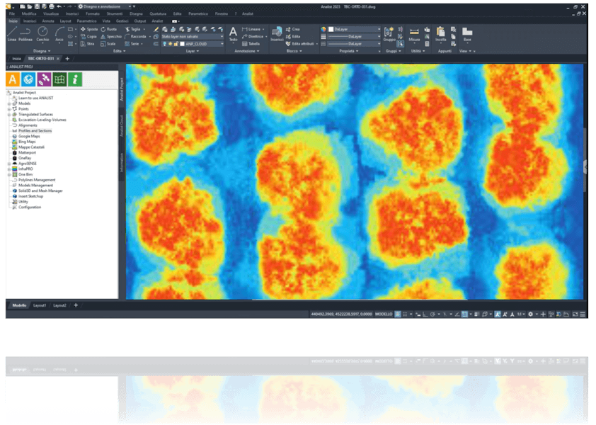
Real-Time Crop Monitoring
Analist 2026 revolutionizes agricultural management through real-time NDVI analysis. It imports and processes data from Drones or Multispectral Sensors to assess crop status, optimize interventions, and sustainably increase yield.
Advanced Tools for Crop Monitoring
- Automatic generation of NDVI maps
- Monitoring of water stress and plant health
- Biomass and vegetation vigor analysis with detailed metrics
- Definition of targeted, localized interventions to reduce waste and optimize costs
Immediate Analysis of Traffic Accidents
In the case of road accident surveys carried out by law enforcement using drones or laser scanners, Analist 2026 enables the import of generated files to perform accurate measurements and reconstruct the accident scene in 3D, speeding up technical operations and supporting the quick reopening of traffic.
Features for Forensic Surveying and Road Safety
- 3D reconstruction of the accident scene: detailed output for analysis and documentation.
- Measurements from all angles to calculate distances, trajectories, and points of impact.
The Most Advanced Solutions
Analist optimizes the work of the most innovative tools in the surveying field for high-quality results and projects, in every application.
Matterport PRO3
The Laser Scanner that Revolutionized Surveying
- Indoor and outdoor surveys
- Scans < 15 seconds
- Automatic alignment
- Automatic generation of Floor Plans, Point Clouds (.xyz), and E57
With Analist you can import and use Matterport data files to estimate surfaces, extract elevations, and perform measurements with a fast and intuitive workflow.
GPS ProTRACK
Intuitive, Powerful, Flexible
- Instant connection, fix in seconds
- Precise staking out, continuous tracking
- Multi-constellation and RTK support
- Also Base-Rover and Base for Drone
Analist imports data acquired by ProTRACK for advanced Pregeo field book management, generation of 3D terrain models, contour lines, profiles and sections extraction, volume calculation and surface leveling.
DJI Matrice 4E with GPS ProTRACK
The Ultimate Solution for Georeferenced Surveying
DJI Matrice 4E is the most innovative tool for 3D surveying and high-definition inspections.
- 20 MP 4/3 CMOS sensor for detailed images
- 48 MP telephoto lens with optical zoom
- Integrated laser rangefinder (up to 1800 m)
ProTRACK precisely captures data to georeference the drone survey. Analist imports and processes the data collected from the equipment, generating 3D terrain models, contour lines, profiles, sections, and volume calculations.
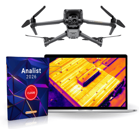
DJI Mavic 3T
The Most Powerful Flight for Thermography
The DJI Matrice 4T is the ultimate enterprise drone for thermography and high-precision technical inspections.
- Multi-camera system: wide-angle, telephoto, and 640×512px IR thermal camera
- Advanced zoom, omnidirectional obstacle detection, and extended flight time
- DJI O4 transmission up to 25 km, RTK positioning for maximum accuracy
With Analist CLOUD and the InfraPRO module, you get professional thermal analysis, generate detailed reports, and precisely detect anomalies on systems, buildings, and infrastructures.
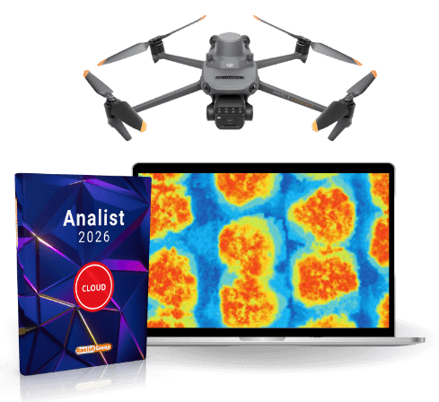
DJI Mavic 3M
Precision Applied to Agriculture
DJI Mavic 3M is the drone capable of capturing the invisible, ideal for Precision Agriculture.
- Integrated RTK Module
- RGB Camera, 4 Multispectral Sensors with sunlight sensor
- Flight time up to 43 minutes with 200 hectares of coverage and 15 km transmission range
Analist and the AGRO Module enable advanced processing of orthophotos to perform detailed analyses and export prescription maps compatible with agricultural machinery and farm management systems.
Unique Features of Analist
- Integrated CAD powered by Autodesk
- Read/Write topographic instrument files
- Import Pregeo files
- Download data from GPS and celerimetric instruments
- Manage celerimetric, GPS and mixed surveys
- Manage measurements for alignment and squaring
- Manage known points
- Insert stations from graphics
- Geometric leveling
- Create measurements on existing stations
- Insert/edit topographic points
- Advanced topographic point management functions
- Automatic code linkage creation
- Point description and symbols from codes
- Export Pregeo field books
- Contour creation
- Advanced coordinate transformations
- Coordinate transformation between geographic systems
- Fiducial points and measurements management (Intertaf)
- Download and create fiducial point monographs (Intertaf)
- Easy and complete Pregeo Update Proposal (Profac)
- Automatic Cadastral Model Generation
- Import cadastral map extract
- Cadastral DB management
- Manage parcels and subdivisions
- Create surfaces from point clouds
- Create model and constraints
- Surface creation
- Advanced management of triangulated models
- Contour line creation
- Advanced contour line management
- Extraction of square/triangular grid models
- Triangular model coloring by elevation or slope
- Export for OneRay
- Model merging
- Import points from ASCII files
- Coordinate group management
- Extract contour lines
- Automatic drawing of ground longitudinal profiles
- Development of cross sections
- Draw design on sections
- Automatic/manual section positioning on profile
- Dynamic section and profile visualization
- Topographic profile management: calculation, drawing, dimensioning
- Extract survey points from section elements
- Ground section calculation: from triangulated model, discontinuity lines, points
- Volume calculation with average sections
- Topographic section management
- Volume calculation on fixed elevation
- Volume calculation between models
- Automatic basin creation
- Automatic stepped surface creation
- Import terrain model from Google Maps
- Track management
- Automatic block insertion on sections
- Design on profiles and sections
- Import maps
- Insert real coordinates of 3 or more known points
- Barycentric georeferencing with deviation report
- View cadastral maps
- Export DWG to Google Maps
- Georeference cadastral maps and DWG using fiducial points
- Create KMZ file
- Import and export GPX files (Garmin)
- Direct export from Gauss Boaga, UTM, Cassini Soldner coordinates to Google Maps
- Garmin on Georeferenced Maps
- “Capture Coordinates” feature to calculate and store the latitude and longitude of any point on the map
Technical Support at Your Service
Phone and remote computer support included!
| Updates and Support | All regulatory and technological updates (software releases) are free for 12 months from the purchase date. Software purchase includes 1 year of dedicated phone and remote computer support, free of charge. |
|---|
System Requirements
Minimum
| Processor (CPU) | 2.5 – 2.9 GHz processor with 8 logical cores (base). ARM processors are not supported. |
|---|---|
| RAM | 8 GB |
| Display resolution | 1920 x 1080 with 16.8 million colors |
| Graphics card (GPU) | 2 GB GPU with 29 GB/s bandwidth and DirectX 11 compatibility |
Recommended
| Processor (CPU) | Base clock of at least 3 GHz or turbo of at least 4 GHz |
|---|---|
| RAM | 32 GB |
| Display resolution | Resolutions up to 3840 x 2160 (with recommended graphics card) |
| Graphics card (GPU) |
8 GB GPU with 106 GB/s bandwidth and DirectX 12 compatibility
DirectX 12 with feature level 12_0 is required for Shaded (Fast), Shaded with Edges (Fast), and Wireframe (Fast) display styles. Be sure to use the latest drivers from the graphics card manufacturer's website. |
| Operating System | Microsoft® Windows® 11 and Windows 10 64-bit. For support information, see the Autodesk Product Support Lifecycle page. |
|---|---|
| Disk Space | 20 GB |
| Additional Notes |
MS-compatible pointing device.
Analist uses the computer's graphics card for several essential graphic operations, including view manipulation, line smoothing, and text/linetype rendering. It is recommended to use a video card with dedicated VRAM to support these operations at optimal speed. |